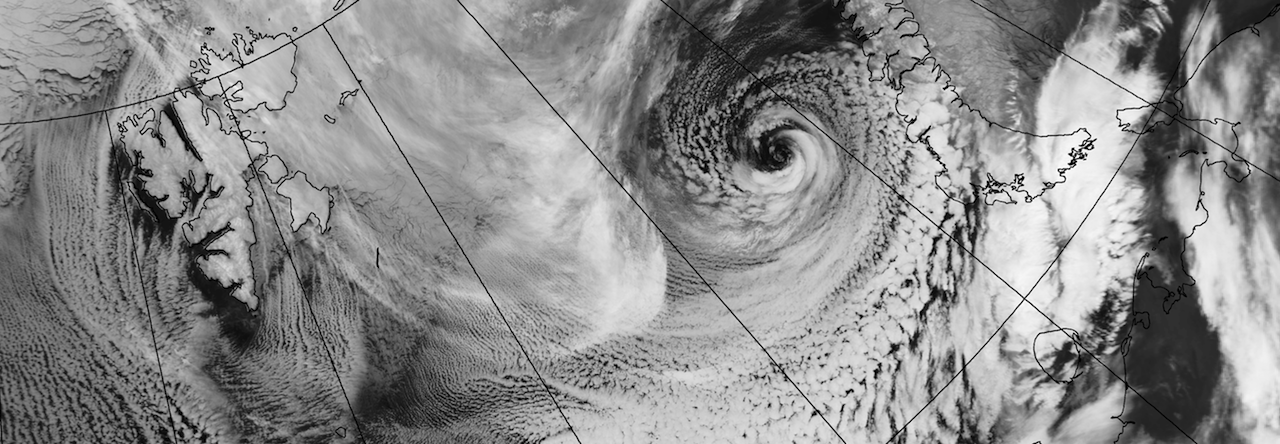
Do hurricanes form in the Arctic? Sometimes polar lows closely resemble hurricanes and a detailed study of one such case has just been published. The polar low (PL) in question occurred on 18-21 December 2002 over the Barents Sea, north of Norway, and is clearly visible at the top right of the image below. This shows spiral bands of cloud surrounding a clear eye at the centre of the storm, which are common features of hurricanes. The study, led by Ivan Fore, used a state-of-the-art weather computer model to answer the intriguing question of what caused this “hurricane-like”PL to intensify. Using this weather computer model they were able assess the details of the polar low dynamics that are not apparent from satellite imagery.

Very strong fluxes of thermal energy from the ocean to the atmosphere were found around the central eye, which are similar in magnitude to those observed in hurricanes. These large fluxes come mainly from the very large temperature difference between the winter atmosphere and open ocean, which can often be around 20 deg C. However, the maximum simulated surface winds of about 90 km/hour were not as strong as the threshold for category one hurricanes of 118 km/hour.
The results showed that the period of rapid intensification did not resemble a hurricane. The dynamics were closer to a standard mid-latitude cyclone (known as baroclinic). However a maintenance period followed the intensification, during which hurricane-like dynamics dominated. The polar low then decayed after moving over land, which cuts off the supply of energy from the ocean.
Would hurricane-like maintenance, or even intensification, have continued if the PL had not moved over land? Theory suggests that in winter the temperature difference between the atmosphere and ocean (and therefore potential for large energy fluxes) is large enough to support a genuine Arctic hurricane. One possible reason that PLs never develop into mature hurricanes is that there is simply not a large enough expanse of relatively warm ocean over the Arctic in winter. Hurricanes take of the order of five days to drift across the tropical Atlantic and slowly intensify, whereas most polar lows move over land or ice in one day.
Citation: Fore, I., J.E. Kristjansson, E.W. Kolstad, T.J. Bracegirdle, O. Saetra and B. Rosting (2012). A ‘hurricane-like’ polar low fuelled by sensible heat flux: High-resolution numerical simulations. Quarterly Journal of the Royal Meteorological Society, published online, doi:10.1002/qj.1876.
